Monday morning: What a weekend! After my flying experience on Friday, I immediately cleaned up my office and went on home. Since day one, we've been told that there's no access to the facility on weekends, so I've spent my weekend at home mulling over all of the strange goings-on at Skybot/Tampa. After only 8 months with the company, I've already advanced to Senior Graphic Assimilator (SGA) and have several times been the top producer in our facility in terms of quantity and quality of visuals processed. As an SGA, I have more free "thinking" time, since I'm supposed to dedicate 2 hours each day evaluating the productions of some of the more junior GAs. I found early on that I could complete my evaluations in much less than the allotted 2 hours, so I spend the extra time trying to answer some of the questions that I've come up with since hiring on. I'm in the midst of one of those slack periods now and have made some interesting discoveries.
One of these discoveries relates to the size of a plot. Recall that each GA is responsible for a geographic area called a plot that measures approximately 1.25 miles by 700 miles. In reading some reports from our European associates, I noted that they naturally describe their plots in meters and kilometers instead of miles. As it turns out, a plot is exactly 2012 meters by 1,113,200 meters. The significance of that is that I once again notice the number 2012, which seems to show up frequently at Skybot. The most obvious is that all of the company addresses are 2012-2112. Then there's the "secret" of room 2012.
Several months ago, I learned that Room 1212 is the access point for us underlings to reach the upper floors (under the assumption that we haven't discovered the flying trick). Each floor has a small break room in room x-12. For example, on the 9th floor where I have my office, the break room is room 912. Up on the 10th floor, it's 1012, 11th floor is 1112, etc. But,when you get to the 12th floor, room 1212 has sofas, chairs, and small tables, but none of the snack and drink machines in the other break rooms. Since the big patio is in the center of the 12th floor with that beautiful open-air atrium up the middle of the upper floors, nobody would think to use room 1212 as a break area anyway. Since it has no food or drink, the logical place to take breaks is out on the patio. In addition to the few tables and chairs, room 1212 has a double door at the rear with a cipher lock next to it. When I'd been with the company a couple of months, I was told one day to go to a meeting in conference room 1300. To get there, I was told to go to room 1212 and a supervisor would escort me up to the meeting room. I went up to room 1212 and waited. The supervisor soon arrived, punched in an 8-digit code on the cipher while covering it carefully so I'd not be able to see the combination, and the door locks clicked open. I followed the supervisor through the double doors and there was an elevator to take us up to the 13th floor. From there, I was escorted directly to conference room 1300, attended the meeting, then was escorted back down to the 12th floor after the meeting.
1,113,200 : Clarification
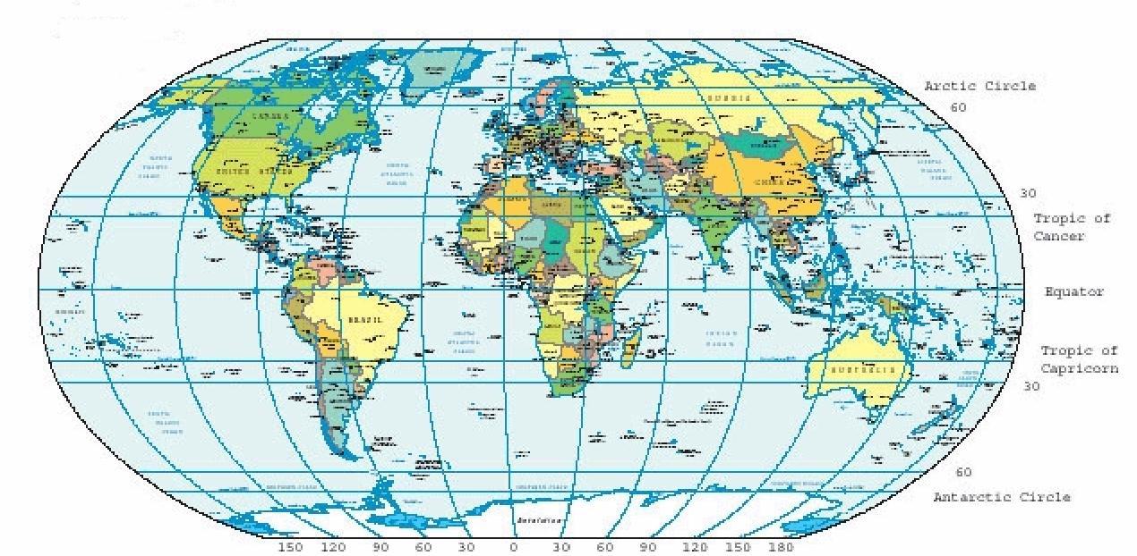
You can look at the map below to get a full understanding of what we're talking about here. I found this world map on Wikipedia (there's a very large version available there, if you're interested) and the sectors on it are actually 30°x30°, so assume that we have 9 of our sectors in each of those shown. I brought up the land-water question above because I realize that there probably aren't facilities like our Tampa building in the middle of the ocean. If we're "covering" those areas, it must be by satellite or some other means. For that reason, I only counted areas that had significant land masses in them. It took me about an hour to count all of the "on land" sectors and I came up with a total of around 124,000 plots. If you look up the records on Skybot, Incorporated, you're shown a company of a much smaller size than that, with no indication of the number of facilities that I'm fairly sure they have. I'm not sure of the reason for these inconsistencies, but they're keeping this secret for some reason, so maybe I'll just keep this information to myself for now.


Coming in Chapter 3
Celestial Spheres, Roswell, 65-Year Plan : How the Mosaic will affect Humanity!
If you have a comment or if you've visited from a location not listed below, please leave a note in the Guest Book on the Orientation page.
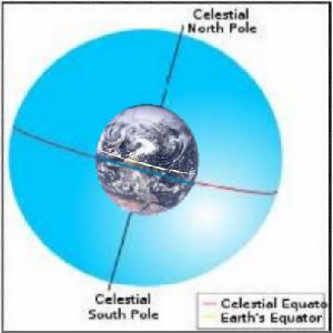
Another, more significant, discovery was to understand how big this project really is. As I mentioned above, I've determined that a plot is 2012 x 1,113,200 meters. So, what does that number say to you? It reminds of my high school geography, when we studied the earth's Geographic Coordinate System and the conjugate graticule (i.e., the latitude/longitude "webbing"). I had learned then that the distance between two latitude lines on the earth is 691.71 miles or 111,320 meters - so, 1,113,200 meters represents 10 degrees. Therefore, if you look at a globe with latitude and longitude lines, a plot measures 2012 meters along a latitude line and exactly 10 degrees North-South. What's more, if you calculate the number of plots processed in Tampa (520) times that 2012 meters, you get 1,046,240 meters.
It took me a while to figure out the significance of 1,046,240. A little wandering around the internet led me to a website labelled Length Of A Degree Of Latitude And Longitude Calculator. Input the "Selected Specific Latitude" and it shows several statistics, one being the number of meters in a degree of longitude. Input 20 (degrees latitude) and it shows one degree of longitude is 104,647 meters, so 10 degrees would be 1,046,470, which is real close to that 1,046,240 number above. Are you keeping up? The length of 10° longitude at 20° latitude (just South of Tampa) is 1,046,470 meters. Divide that by 2012 and you'll get 520, which is the number of plots processed in Tampa.
The Tampa Sector
Continuing the process, I looked up 14 of the facilities in North America (Ottawa Canada, Chattanooga, Matamoros Mexico, New Bern NC, Nassau, Traverse City MI, Willmar MN, etc.) and plotted them on a map, outlining the 10°x10° sector for each. Start the display on the map here to see the results. Lo and behold, I was soon covering most of North America, and each sector had exactly one Skybot facility. I checked some of the addresses that I had in Europe, Asia, and other parts of the world and found the same thing to be true there. It soon became obvious that there's one of these Skybot facilities in every 10°x10° geographic sector in the world. Although the number of plots, and therefore GA staff members, varies according to the width of the 10° sector at different latitudes, it's fairly straight-forward to calculate the total number of plots/staff in the world to be nearly 248,000. A quick count on the globe showed me that about half of those are over land and half over water, so even if you only count the ones on land, that still adds up to 124,000 GA staff members! That's a fair-sized project!
It occurs to me that I'm delving into some areas of Skybot business that my management may not be too pleased about. I have no idea how much they monitor internet activity, but I guess my checking of coordinates for facilities around the world, calculation of areas covered by the facilities, and sudden interest in world maps and geographic coordinates might raise their curiousity. Consequently, I've decided to do all of my "investigating" at home on my own computer, where my actions hopefully won't be monitored.
You may be wondering why I'm so interested in learning more about Skybot, Inc. and, specifically, this project Skybot that I'm part of. Well, I guess it's primarily my natural curiousity regarding some of the peculiar things that I've seen since joining the company and the project. If you consider that we've got 124,000 or so people around the world gathering and assimilating these visuals, without any real understanding of what the final objectives are, that's a little strange. It's much like the way that the Government compartmentalizes classified projects, so each person only knows about the part they're working on, with no real knowledge of the big picture and how their piece fits into the whole. As we continue to put the visuals together and create larger and larger combined visuals, which we're now calling mosaics, one has to wonder just how large these will ultimately be and what their purpose is.
Have you noticed that if you go to Wikipedia and ask for a location (like Tampa, Florida), there's a hyperlink on the coordinates for the location? Well, I clicked on that link and it takes me to a page labelled Geohack - Tampa, Florida. On that page, there's a list of 29 map providers that you can access to see the location in satellite view, map view, aerial view, weather, topology, and more. Plus, although some of these appear to share their satellite views, there are differences, indicating that there have probably been large projects of many people putting together these photos and storing them in databases so they can be accessed. I don't know exactly how all that was accomplished, but we're probably talking about projects as large or larger than our Skybot project. The difference between those projects and ours is that they probably had a good idea of the intended use of the results of their project. I doubt, however, that the original producers of all these satellite views had any idea that people around the world would be able to easily access those views on the internet as we now do. Likewise, the mosaics that we're now producing may have some long-term uses that the project planners haven't yet thought of. My knowing more about the near-term intended uses might allow me to come up with some new ideas that would benefit both me and the company.
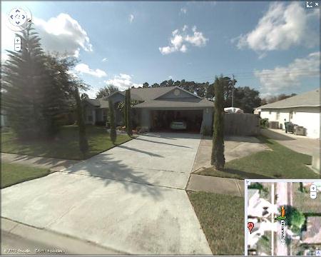
The option on the internet maps that really impresses me is the one that allows the viewer to see a "street view" of the location. If you've never looked at a street view in Google Maps, you ought to try it out. It's amazing! Click on that Google Maps link, type in your address, choose more, and select "Street View" - Voila! There's your house! I don't know if there's a way to know exactly when the photo was taken, but I can usually spot something that lets me know, like what cars are in the drive, etc. In my case, I'm looking at my house right now and see a tree there that I cut down about 3 months ago, so know the photo is at least 3 months old. Looking further down the street, I can see some things that were changed a year ago. Look closely enough at an area with which you're familiar and you can probably fairly closely estimate the origination of photos you're viewing.
Can you imagine how many photos it takes to provide street views like this for the entire world? Wow! I can't imagine how they do that and how much it cost to produce.
So I wonder what I'd see if I looked at street views of some of the Skybot facilities ... oops, maybe I'll do that from home. Better get back to work right now.
A Familiar Street View
Home now and looking at some satellite views of our Tampa Skybot facility. I found one before they did the landscaping. I started work here in February, 2011 and they did the landscaping a month or so later. In that pre-February satellite view, I see some bubbles on the roof that look like skylights. They're circular, look like they're about 5 feet across and there are about 20 of them. But then I found a view that was obviously taken in June, about the time they were extending the parking lot. Now, I see fewer, larger skylights on the building. In this June view, there are only 10 and they're about 10-15 feet across. I'm not at all sure what those are, but it sure makes me want to get up on the top of that building and see what's going on.
Now, let's look at some of the other facilities. Looking at the one in Lyon, France, I see similar skylight bubbles, but more of them. No telling how old the photos are, of course. The one in Alice Springs, Australia only has 3 bubbles, but they're very large and nearly cover the top of the building. It's hard to tell if the number of bubbles depends on the location of the facility or the age of the photos. You can be sure, however, that I'm going to find a way to get up to the top of our building at some point soon to see what those bubbles are.

Had a little surprise this morning ... since I'm a Senior GA and am monitoring progress on others, including those in offices outside of North America, management has given me access to their Mosaic Production Status (MPS) programs. With these programs, I can bring up holographic maps of any area of the world and point to any Skybot facility location to get a read-out of the ranking of GAs at the facility, as well as some percent-complete statistics. These statistics tell me how nearly "complete" their activity on our project is, as well as compare that to completion data from previous months and note month-to-month progress. What they may not realize is that I can put this data together with what I learned this weekend about "roof bubbles." It appears that the number of roof bubbles is inversely proportional to the percent complete (e.g., Lyon has more bubbles than Tampa and has a lower percent complete, while Alice Springs has fewer and is nearer completion).

Of course, this simply highlights the question of what completion means. When the activities at a specific facility are complete, does that mean they're down to one bubble? Where does our job go when we're complete? I suspect there'll be other projects in the future, but there's been no mention of that as of yet. I guess my inclination would be to go up on our roof and count bubbles to see how close we really are to completion. I also suspect that seeing those close up and from the inside of the building might shed light on exactly what they are.
A little more experimentation with MPS and I've figured out that I can obtain statistics on larger areas by zooming out and "circling" the area with the CATs. Circling Europe, I find they're approximately 58% complete. North America is about 51% and Australia is 47%. That fits with what I learned earlier regarding the three cities. So, what if I zoom way out and circle the entire globe? Overall, the project is apparently 49% complete. Since they started the project just before I arrived and I've been here 10 months, that would indicate that we've progressed 49% in 11 months or so, so probably have about another year to go if we continue at the same rate. Interesting ...
That symbol above has become a sort of logo for our project. I'm not sure the origin or meaning of it, but it started showing up on documents and other communications a few months ago. I've decided to use it in my writings here to denote the passage of time. So, a little time has passed since I started experimenting with the MPS.
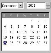
I've been spending a lot of my time thinking about those roof bubbles and about how/when I might get up on our roof to check them out. I asked my supervisor if he'd ever been up there and he said he'd never been above the 13th floor and didn't know anyone who had other than the upper level managers. And, speaking of upper level managers, he mentioned that all of them are traveling to someplace in Africa during the December holiday season for some sort of annual management summit. It seems that a few stations in Africa are the only ones that will be operational during the season, with all other facilities having a two-week shutdown period from December 19th through New Year's Day, returning to work on Monday, January 2nd, 2012. They need a volunteer to come by the office about twice a week to resynchronize the mosaic. Not being sure what that meant, but eager to have that opportunity to be in the facility alone, I immediately volunteered for this duty. He said that one of the upper managers would be down to my office to explain to me how to do the resync and how to access the facility during the shut-down period.
Back in my office, I sat marvelling at my good fortune. Without any effort on my part, I've been given the opportunity I was looking for -- to be in the facility alone, so I can do some investigating without worrying about being caught. It's a bit of a surprise to me that the company would schedule such a meeting during holidays when most employees want to spend time with their families, but I guess I'll file that with my other strange, unanswered questions. Just got a note on my display that there's a manager on his way down to meet with me.
As soon as the manager walked in, I realized that I'd never before had a one-on-one conversation with any of the management. All of my interfaces with upper levels had been through a supervisor, so this was indeed a new experience. I was impressed by the forcefulness of his attitude and how comfortable I felt talking with him. Instead of feeling the nervousness I'd expected in meeting with one of the managers, it only took a few minutes to feel like we'd known each other for years and he was an old friend. He explained to me that the synchronization was necessary since some of the facilities would be continuing to process visuals while ours was on a break. To maintain the integrity of the total mosaic, it was necessary that each of the idle facilities be resynchronized every 3-4 days. I'd perform this resync using the MPS, by putting my left CAT on our facility and right CAT on the facility in Abidjan, Côte d’Ivoire (Ivory Coast). He said that the Abidjan facility would be up and running, and that was where all of the Tampa management was going to attend the summit. He said that doing the resync every 3 days would be best, although there'd really be no problem as long as I didn't let it go more than 5 days. Longer than that and the system would require some major reconfigurations that they'd like to avoid. He gave me the contact information on two other SGAs in Tampa that I could call if I couldn't keep that schedule for any reason.
As far as getting into the facility, that process is a little of a surprise. He asked me for my cellphone and then showed me an authentication token that he has on a chain around his neck. He then plugs his token into the bottom of my cellphone and installs what he refers to as embedded authentication software. This software being in my phone will allow access to the facility until it re-opens after the shutdown on Monday, January 2, 2012, when it will then automatically deactivate. Carrying the phone will allow me to carry my CATs out of the facility, which I then use to get in when the building is locked. I walk up to the front door, place either CAT on the door, and it automatically unlocks. Not only does this tell me how to get in, it explains how the managers are able to walk out each night with the CATs, so they can fly from the 12th-floor patio up to their offices each morning. They all must carry one of those authentication tokens and, as I suspected, any tokenless person trying to walk out with their CATs would probably set off an alarm. I'd heard the alarm go off before, but had never known precisely what caused it. This answers several of my lingering questions, so I'm very glad I was offered the option of handling this assignment. He also cautioned me to not wear my CATs while out of the office, except when opening the door.
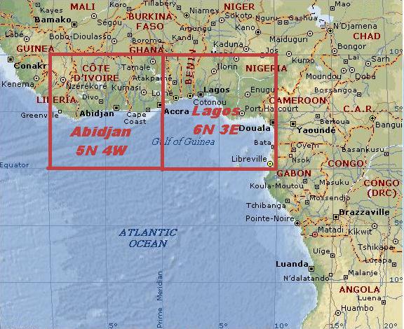
With that, he asked if I had any questions, which I didn't, and he thanked me for my efforts and left. So, here I sit, trying to digest all that I've just heard. Once again, more questions. Where in the world is Abidjan and why is it so important? Checking Wikipedia, I learn that Abidjan is quite a significant city. To quote Wikipedia, "Abidjan is the economic and former official capital of Côte d'Ivoire (the current capital is Yamoussoukro). It is the largest city in the nation, and the third largest French speaking city in the world. It has, according to the authorities of the country in 2006, 5,068,858 residents in the municipal area and 3,796,677 residents in the city. Only Lagos, the former capital of Nigeria has a larger number of inhabitants in this region. Considered a cultural hub of West Africa or Africa, Abidjan in the 21st century is characterized by high industrialization and urbanization." What's more, it's the home of the Skybot facility that handles the sector immediately to the North and West of the 0° latitude, 0° longitude point. Looking a little further, I learn that Lagos, Nigeria is the home of the Skybot facility immediately North and East of the 0° latitude, 0° longitude point. So, these are like the root facilities of the entire Skybot network and the home of our project. It's my guess that Abidjan is the home point for western hemisphere facilities and Lagos is the home for the eastern hemisphere. Interesting ...
Reading further in Wikipedia, I see that "Lagos is the most populous conurbation in Nigeria with 7,937,932 inhabitants at the 2006 census. It is currently the second most populous city in Africa (after Cairo), and currently estimated to be the second fastest growing city in Africa (7th fastest in the world)." Reading on, I find that "As Abidjan is inhabited by people from a wide array of different ethnicities, the French language is used as the language of communication in the metropolitan area, which is the third-largest French speaking metropolitan area in the world after Paris and Kinshasa." As it turns out, Kinshasa is also the home of one of our facilities, covering the sector from the Equator South 10° and between longitude 10° and 20° West. If you'll move your mouse over that graphic above, you'll see the Kinshasa sector outlined. And on the story goes ... Here are three huge cities that are the home of over 20 million people, major economic and political centers, the home of what are probably the primary Skybot facilities, and I've never heard of them (Have you?). It seems that since about 1950, these cities have been doubling in size every 6 or 7 years. Two of them were once the capital of their respective countries, but those capitals have now moved elsewhere. It's almost like someone decided they were getting too much attention, so they moved part of the spotlight to other areas. Maybe it's just my imagination, but I think these deserve a little more study when I have the time and opportunity. What happened around 1950 that would explain their amazing growth? Did Skybot select them because of their location and size, or was their growth and popularity somehow stimulated by Skybot? I don't think Skybot and its originators were around in 1950, but who knows? As I said, it deserves more study later.
Monday, 2011-19-12: So, the shutdown is finally here and I'm on my way in to perform my first resynchronization action. When I left the building just last Friday with my cellphone and my CATs in my pocket, I walked out with no problems, as predicted. Now, I'm standing here holding one of the CATs up to the door, feeling a bit strange. Click, the door unlocks, and I'm inside. Wow! It's eerie in here when nobody is around. The lights are on in the hallways and all looks normal, except that it's totally quiet and there's absolutely nobody else here. I noticed as I drove in that there are no other cars in the parking lot and no evidence of anyone else being about. Up the elevator to 9, into my office, and boot up my holographic computer. Sure enough, the CATs work as predicted, with a huge RESYNC IN PROGRESS showing up on the display as soon as I place my CATs on the proper locations as directed. The process only takes a few minutes and now I'm free to go ... or whatever. Do I go exploring the upper floors now? I know they have surveillance cameras throughout the building, but I think they're all turned off now since there's nobody here. How about if I go up to Patio on 12 and see how things look from there?
From the patio, I can look up the center of the building where everything looks really dark. Though it's midday, there are no windows on the atrium and all of the upper floor office doors are closed, so the only light is shining up from the patio. I sit there studying the upper floors, looking for any sign of life or activity, and see none. I notice that none of the cameras here show the customary blinking red light, so I conclude that they're all turned off. As I sit here looking up into the dark, I make another discovery. I was looking carefully at each floor and subconsciously counting the floors, When I get to the top, I've only counted 20! Where's the 21st floor? I recount and sure enough, no 21st floor. How strange.
Well, I just don't have the courage to make a flight up there right now. I think I'll leave for today, think things over, make a little bit of a plan, and try that exploration another time.
I saw little of the 13th floor, but did notice that their elevator only went up to the 20th floor. I also noted that a security token was required to operate the elevator, so even if one got through the cipher-locked double doors, one of those tokens was still required to reach the management areas upstairs. I asked the supervisor why it only went up to the 20th floor and he said he'd never seen it, but that he'd been told that the 21st floor access was through room 2012, which had a setup much like room 1212, with the double doors and cipher lock. There was that 2012 again! I guess the reason that this recurring number 2012 catches my attention is because of all of the hoopla surrounding the year 2012, when some sort of earth-shaking event or series of events are supposed to occur. Some predict it as the end of the world, but others view it as some sort of epiphany when great secrets will be revealed. Whatever that's all about, I just think it curious that the number keeps popping up around Skybot. I can't help but wonder if our project is somehow related to the year 2012. I guess I'll file that under things to think about later.

Security Tokens
Today's the day!
It's Christmas Day and 9 days since shutdown, so I'm due to do another resync today. I came into the office on the 19th and the 22nd, did the resync, wandered around the building (floors 1-12 only), and convinced myself that I was the only one here. Today being Christmas Day, I'm really sure that nobody else is here. I've checked each floor from 1 through 12 just to be doubly sure, so now's the time to do my upper floor exploration.
On the Patio on 12 now, CATs in hand, arms extended, and ... up I go! It was way back in October when I first learned that I could fly here using the CATs, so it's taking me a few minutes to once again feel that I'm in control of my motion. It's not long before I'm in complete control, moving the desired direction without effort. Up I go to the 20th floor ... wow! Looking down at the patio from here, it really looks much farther than it does when I was down there looking up.
Around the walkway I go, straight to room 2012, where I should find the access to the 21st floor and roof. Once in the room, I find the same cipher-locked double doors that I saw down in room 1212. Nothing else to do but try the cipher. Looking at it, I immediately notice that the buttons 0, 1, and 2 are much shinier than the other 6 keys. Is it possible? I try combination 2012 and press the * key, but no luck. Then, I remembered that the supervisor used some 8-key number when he unlocked the door in 1212 so long ago. Just for kicks, I try 20122112 and * -- Presto! The door clicks and is unlocked. Going through the door, instead of an elevator, I see stairs. Up I go and there are glass doors that provide a view of the 21st floor, but no cipher lock. I pull the door, but it's locked. Then, I notice the similarity between these doors and the outside front doors ... maybe my CATs work here. I still had my authenticated cellphone in my pocket and my CATs in my hands, so I hold one of the CATs up to the door. CLICK! It's open!
Walking through the doors, I find myself under a huge dome. It seems that the 21st floor is in fact the roof and I'm under one of those bubbles I've seen in the satellite photos. Looking up, I see thousands and thousands of visuals ... this appears to be the FULL MOSAIC of all the visuals that have been processed in Tampa! The dome (bubble) is hundreds of feet across and walking under it, I recognize many of the visuals that I've seen over the past months. As I walk from one side to the other, I realize that there are empty spots here and there, so the dome is actually only about 50% covered with visuals.
Reaching the far side of the dome, it seems that I've only walked about half as far as I'd expect to cover the entire building. I'm guessing that there are more bubbles up here, but how to I get to them? Walking right up to the edge of the dome, I strain to look through it and sure enough, I can see another bubble beyond. Then I notice that the dome is suspended about 3 feet off of the surface of the roof. Can i fit under the edge of the dome? I attempt to slip under, but find that I'm going to bump up on that dome just a little. But there's no bump! To my surprise, I can go right through! This entire dome is a hologram! Amazing!
Carefully, I step through the side of the dome, walk a few steps, and enter the next dome. Under it, I find more of the same. Hundreds of visuals and a few empty spots. This dome seems more complete than the other, but it's difficult to estimate how much of it is covered with visuals and how much is empty. It would be nice if I could somehow get a bird's-eye view of this whole setup. hmmm .... Stepping back outside, I put on my CATs and feel the same electric buzz that I felt inside the atrium. Holding my arms up, I begin to rise, just as I did inside the atrium. Wow! I can fly outside! How far can I go?
Up, up, up .... above the domes ... from here, I have a clear view of the entire top of the building. There are only those two domes and together they cover the entire top of the building, except for a wall around the very edge of the building. That must be what shows from the outside, making it appear that the 21st floor is just like all the others. From up here, the domes a dull grey color, with no indication of the colorful visuals spread all across the inside. I notice that at one point, the two domes are just barely touching, with a small area shared between the two. I'll bet that these will eventually merge into one single dome that covers the entire top of the building. A huge mosaic containing all of the visuals from all of the inhabitants of our sector! And what then?

©,
Robert Hoffman Consulting, Inc., All Rights Reserved.


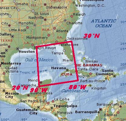
CONCLUSION: What all that calculating tells me is that our facility in Tampa is responsible for a sector that runs 10° North-South and 10° East-West. Looking up Tampa on Wikipedia, I find that we're at 28°N, 82°W, so it appears that we're responsible for the 10°x10° sector between longitude 80°W-90°W and latitude 20°N-30°N as shown on the map.
UIM
North American Sectors and Facilities (Use thumbnails on top to select a specific image)
Visits recorded as of: July 7, 2017
1. Alabama
2. Arizona
3. Arkansas
4. Australia (New South Wales)
5. Australia (Queensland)
6. Australia (South Australia)
7. Australia (Victoria)
8. Australia (Western Australia)
9. Austria (Wien)
10. Bahamas (New Providence)
11. Belgium (Brussels)
12. Belgium (Namur)
13. Bosnia-Herz (Sarajevo)
14. Brazil (Sao Paolo)
15. Bulgaria (Vidin)
16. California
17. Cameroon
18. Canada (Alberta)
19. Canada (BC)
20. Canada (Manitoba)
21. Canada (New Brunswick)
22. Canada (Ontario)
23. Canada (Quebec)
24. Canada (Saskatchewan)
25. Chile (Bio-Bio)
26. Colombia (Cundinamarca)
27. Colorado
28. Connecticut
29. Croatia (Grad Zagreb)
30. Cyprus (Nicosia)
31. Czech Republic (H M Praha)
32. Czech Republic (Lib. Kraj)
33. Denmark (Århus)
34. Denmark (Fin)
35. Denmark (Kobenhavn)
36. Egypt (Al Qahirah)
37. Estonia (Harjumaa)
38. Estonia (Parnumaa)
39. Finland (Southern Finland)
40. Florida
41. France (Aquitaine)
42. France (Auvergne)
43. France (Bretagne)
44. France (Haute-Normandie)
45. France (Ile-de-France)
46. France (Midi-Pyrénées)
47. France (PACA)
48. France (Pays de la Loire)
49. France (Rhone-Alpes)
50. Georgia
51. Germany (Baden-Wurttemberg)
52. Germany (Bayern)
53. Germany (Hessen)
54. Germany (Lower Saxony)
55. Germany (Niedersachsen)
56. Germany (Nord-Westfalen)
57. Germany (Rheinland-Pfalz)
58. Germany (Saarland)
59. Germany (Sachsen)
60. Germany (Schleswig-Holstein)
61. Greece (Athens)
62. Hawaii
63. Hong Kong (Sham Shui Po)
64. Hungary (Budapest)
65. Idaho
66. Illinois
67. India (Delhi)
68. India (Maharashtra)
69. Indiana
70. Iowa
71. Iran (Hamadan)
72. Iran (Tehran)
73. Ireland (Laois)
74. Ireland (Limerick)
75. Italy (Lazio)
76. Italy (Marche)
77. Italy (Sardegna)
78. Japan (Fukuoka)
79. Kansas
80. Kentucky
81. Korea, Republic of (Seoul)
82. Kuwait
83. Latvia (Riga)
84. Louisiana
85. Maine
86. Malaysia (Federal Territory)
87. Maryland
88. Massachusetts
89. Mexico (Guanajuato)
90. Mexico (Veracruz-Llave)
91. Michigan
92. Minnesota
93. Missouri
94. Nebraska
95. Netherlands (Groningen)
96. Netherlands (Noord-Brabant)
97. Netherlands (Noord-Holland)
98. Netherlands (Zuid-Holland)
99. New Jersey
100. New Mexico
101. New York
102. New Zealand (Auckland)
103. New Zealand (Nelson)
104. New Zealand (Porirua)
105. Nevada
106. Norway (Finnmark)
107. Norway (Telemark)
108. Norway (Sor-Trondelag)
109. North Carolina
110. Ohio
111. Oklahoma
112. Oregon
113. Pakistan (Punjab)
114. Pennsylvania
115. Philippines (Manila)
116. Poland (Dolnoslaskie)
117. Qatar (Ad Dawhah)
118. Rhode Island
119. Romania (Bucuresti)
120. Saudi Arabia (Ar Riyad)
121. Singapore
122. Slovakia (Bratislava)
123. South Africa (Gauteng)
124. South Africa (Western Cape)
125. South Carolina
126. Spain (Cataluna)
127. Spain (Galicia)
128. Spain (Toluca)
129. Sri Lanka (Colombo)
130. Sweden (Gavleborgs Lan)
131. Sweden (Kalmar Lan)
132. Sweden (Stockholms Lan)
133. Sweden (Uppsala Lan)
134. Switzerland (Zurich)
135. Syria (Dimashq)
136. Taiwan (Taipei)
137. Texas
138. Thailand (Krung Thep)
139. Turkey (Adana)
140. Ukraine (Krym)
141. United Kingdom (Bromley)
142. United Kingdom (Edinburgh)
143. United Kingdom (Cardiff)
144. United Kingdom (Hertford)
145. United Kingdom (London)
146. United Kingdom (Sheffield)
147. United Kingdom (Yorkshire)
148. Utah
149. Uzbekistan (Toshkent)
150. Wisconsin
151. Vermont
152. Vietnam (Dac Lac)
153 Vietnam ( Ho Chi Minh City)
154. Virginia
155. Washington
156. Wyoming